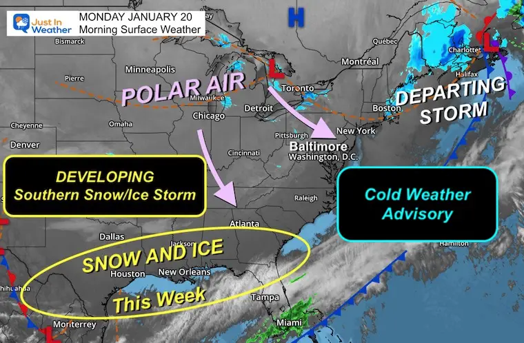
An intense blast of arctic air is sweeping across much of the United States to start the week, following a storm system off the East Coast that dumped snow over the Mid-Atlantic and Northeast over the weekend. But as the those regions dig out from the snow, a rare and significant winter storm will threaten the Gulf Coast states and the Southeast beginning Monday night.

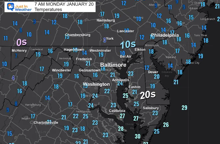
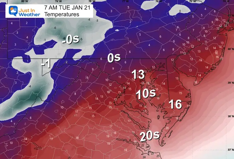
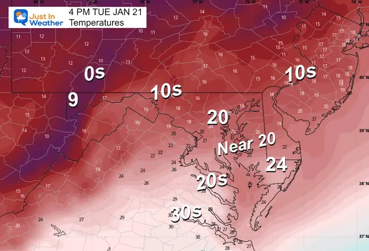
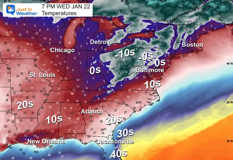
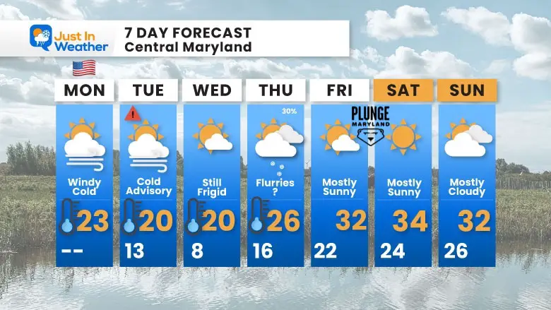
The bitterly cold air mass is affecting the western, central and eastern United States this week, causing temperatures to plunge far below normal for January. On Monday, high temperatures are expected to be 20 to 30 degrees colder than average.

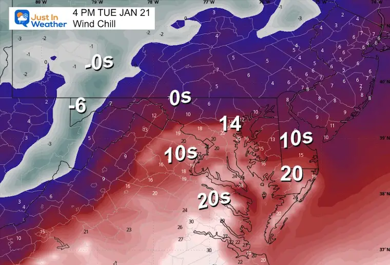
Across the northern Plains and Upper Midwest, temperatures are expected to be in the negative teens and single digits. The Rockies, central Plains and Midwest are likely to see highs in the single digits to teens, while the East Coast, New England and the Mid-Atlantic brace for temperatures in the teens and 20s.

The snowstorm that moved through the Northeast and Mid-Atlantic on Sunday left some of the largest accumulations of the season. Accident, Md., just south of the Pennsylvania border, recorded 14.5 inches. In New York, the largest totals were in the southeast part of the state, north of New York City, with around eight inches in Fahnestock State Park, Highland Mills and Hopewell Junction. Central Park recorded 1.6 inches.

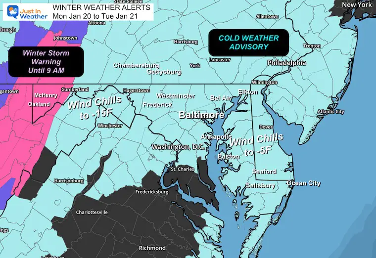
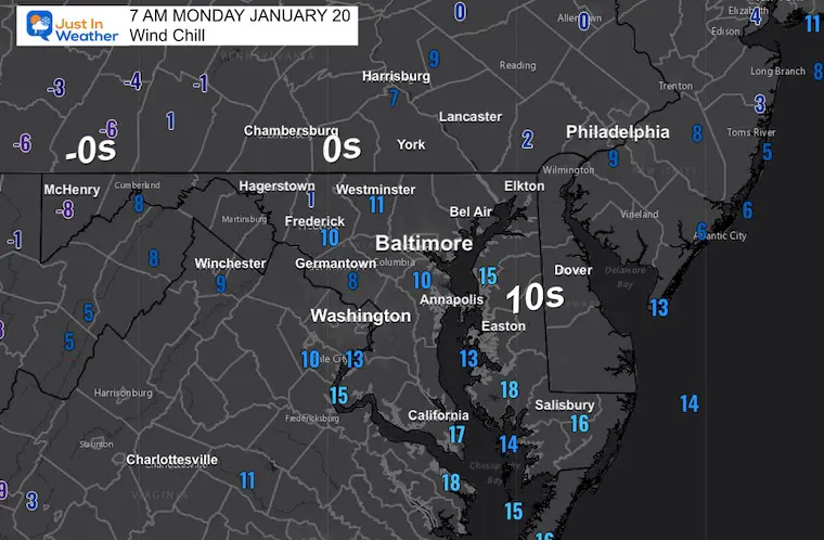
In Washington, D.C., which received a little less than an inch of snow on Sunday, organizers of President-elect Donald J. Trump’s inauguration, moved the swearing-in ceremony indoors for the first time since 1985. “Bitter cold conditions are expected” on Monday, the National Weather Service said, warning that highs in the teens to low 20s were likely, with gusts up to 30 m.p.h. likely bringing wind chills down to single digits and below zero.

Across the northern Plains and Upper Midwest, temperatures will only reach the negative teens and single digits. The Rockies, central Plains and Midwest will see highs in the single digits to teens, while New England and the Mid-Atlantic brace for temperatures in the teens and 20s.

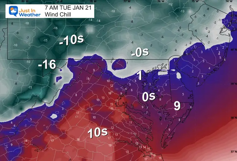
The frigid temperatures will feel even more severe because of dangerous wind chills, particularly in the Rockies, northern Plains and Upper Midwest. These areas are forecast to have wind chills as low as 30 to 55 degrees below zero through Tuesday morning, levels that pose a severe risk of frostbite and hypothermia to anyone with exposed skin, the Weather Service warned. Even areas as far south as the south-central Plains and the Ohio Valley will experience subzero wind chills by the middle of the week.

The unusually cold weather is extending into regions less accustomed to harsh winter conditions, including the Gulf Coast and northern Florida. Numerous freeze warnings were in place, as subfreezing morning temperatures are likely to threaten sensitive plants and exposed plumbing. These frigid conditions are expected to persist for the next few days over eastern and southern parts of the country.

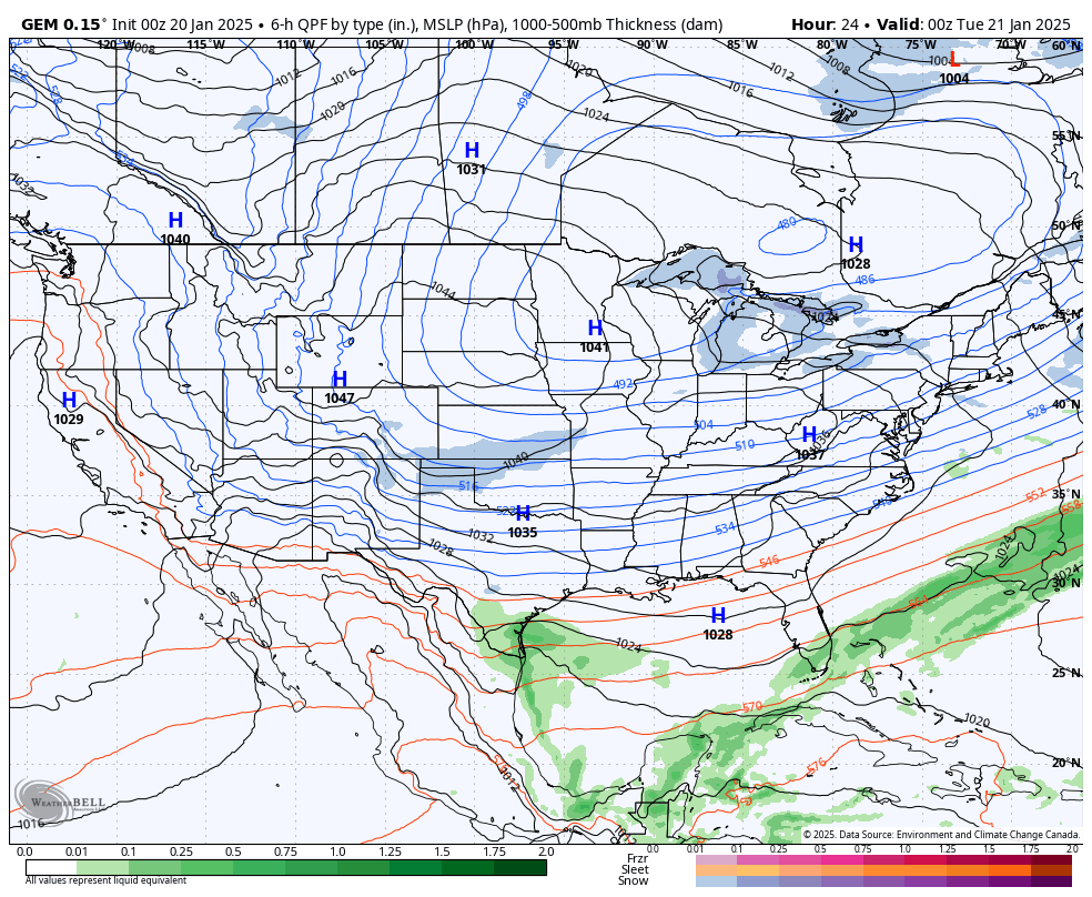
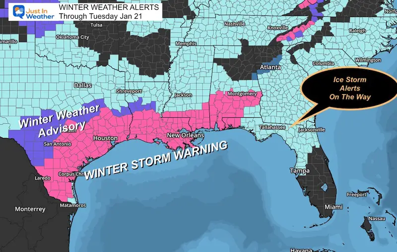
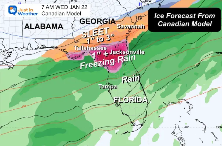
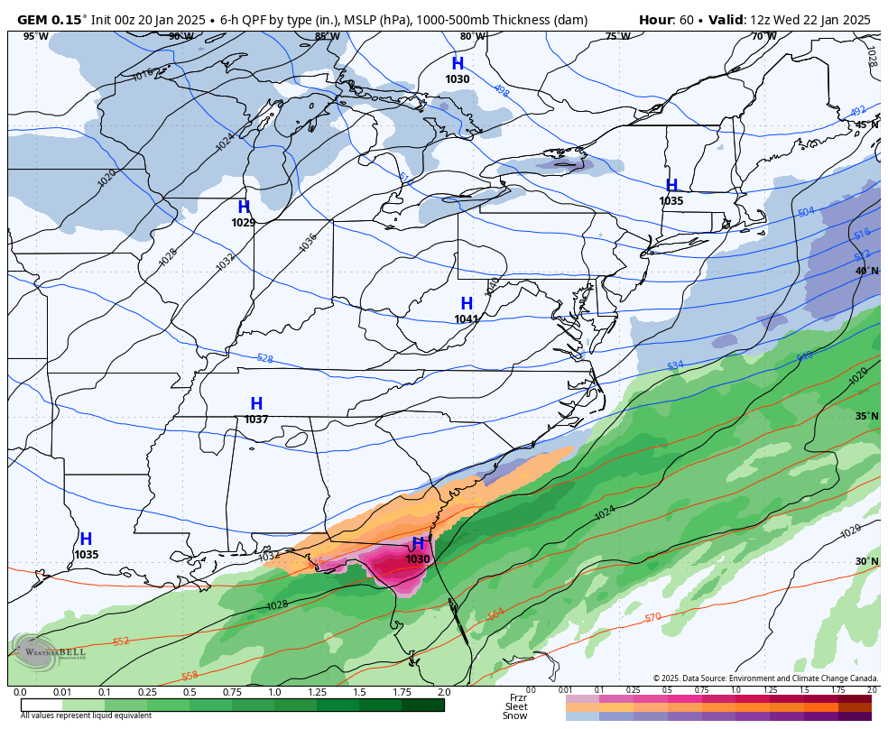
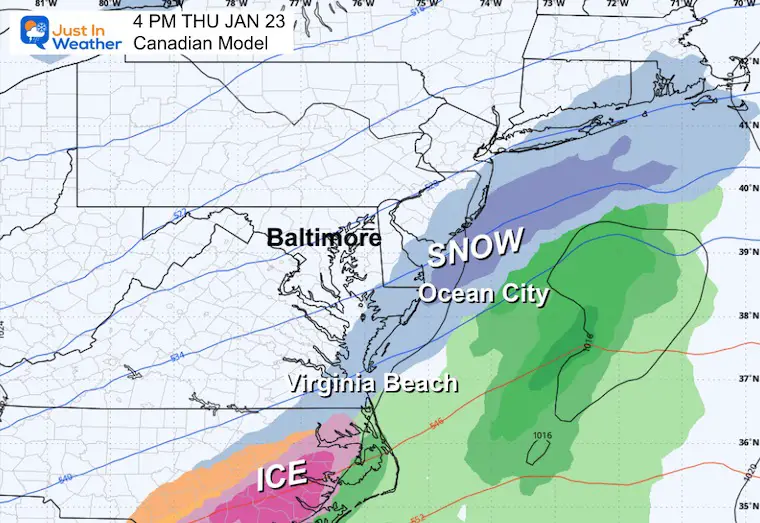
In addition to the dangerous cold, the combination of arctic air and a storm system will result in the potential for a rare and significant winter storm over the Gulf Coast states and the Southeast, beginning Monday evening in eastern and southern Texas and spreading eastward along the coast, reaching the Southeast by Tuesday and Wednesday.

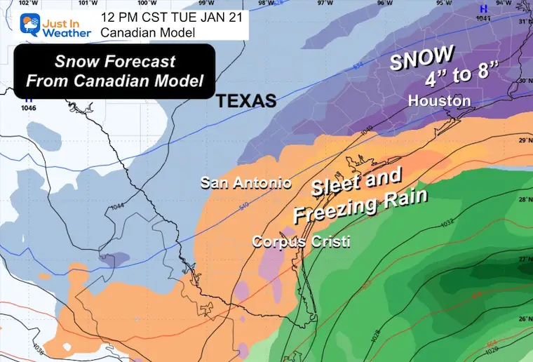
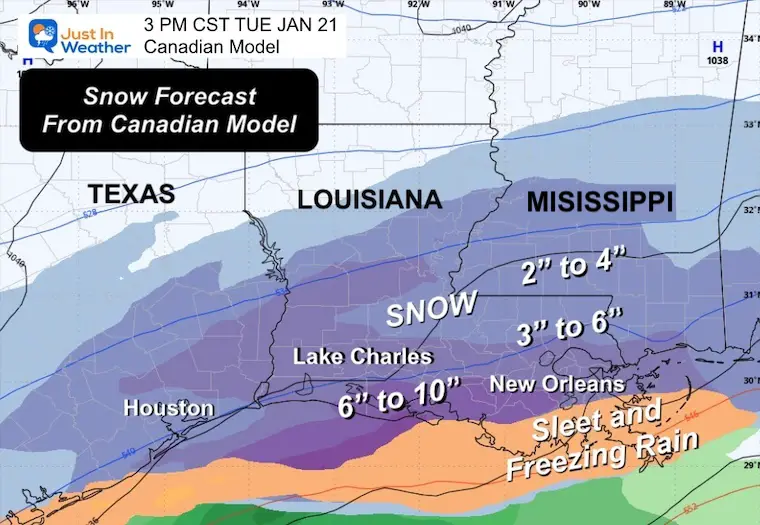
The storm is forecast to sweep across Texas, Louisiana, Mississippi, Alabama, north Florida, Georgia and the Carolinas, said Marc Chenard, a meteorologist at the Weather Service. Heavy snow is expected along and near the Interstate 10 corridor, while sleet and freezing rain are forecast for parts of southern Texas, southeast Georgia and northern Florida.

These conditions are likely to lead to major travel disruptions, with flight delays and cancellations also anticipated, given these areas are not equipped to handle winter weather, Mr. Chenard added. Strong winds and the weight of snow on tree limbs may bring down power lines and cause sporadic power outages.

The National Weather Service has issued winter storm warnings for southern areas of Texas, Louisiana, Mississippi, Alabama and northwest Florida. Total snow accumulations over southeast Texas and southwest Louisiana are expected to be between two and six inches.

The bitter cold and winter storm impacts are expected to linger across the Southeast and eastern United States until at least midweek. Dangerous driving conditions and travel disruptions are likely to continue for a few days in the South after the storm clears, Mr. Chenard said, “given the cold air still in place, it might take a little while for things to melt out.”


Source link


January 20, 2025

Monday Morning Report

Our recent snow has come and gone, with a boom inland and a bust for metro areas. While Baltimore only got 1 inch at BWI, 2 inches fell in the city, and up to 6 inches fell inland. I will have a full recap and grade my forecast later this morning.

The net result of a little or a lot of snow is simply this: Anything that was wet and untreated is icy now! We are in the deep freeze, and it will get colder. A new Cold Weather Advisory goes into effect for the entire region tonight, as wind chills will drop well below zero. We will stay below freezing all week!

Polar Vortex ‘Influence’: The actual circulation will be in Canada and will bring the coldest air Wednesday morning; then we will modify a little but stay cold into the weekend

This cold air is feeding into a rare snowstorm for Texas and the Gulf Coast. This will include heavy snow from Houston to New Orleans and an ice storm for North Florida. More on that below.

Winter Weather Alerts

  • The old Winter Storm Warning remains in the mountains this morning.
  • Cold Weather Advisory kicks in tonight. This is a new alert that replaced the former alerts for wind chills. “Feel like” temps may drop to -5F in metro and coastal areas. Down to -15F in the mountains.

January 20 Cold Weather Advisory


Morning Temperatures and Wind Chills

January 20 weather temperatures Monday Morning

January 20 weather wind chill Monday Morning


Morning Surface Weather

The Polar Air is dominating as expected. Our old storm is racing east of Maine.

A new storm will make the headlines this week across the Gulf Coast.

Snow and ice will affect the Deep South on Tuesday and Wednesday.

January 20 weather Monday morning Cold Advisory


Storm Animation

Monday Evening to Wednesday Evening

January 20 weather southern snow ice storm


Southern Snow and Ice Storm

Winter Weather Alerts

The Winter Storm Warning is in effect for Houston and New Orleans. Today, more alerts will extend to Northern Florida.

These areas DO NOT have snow removal equipment. So unless equipment arrives from other locations to help, it will stay for days.

January 20 Winter Storm Warning Texas Louisiana


Snapshot Texas

Yes, models do show 4 to 8 inches of snow near Houston and an Ice Storm for Corpus Christi.

January 20 snow freezing rain Texas


Snapshot Louisiana

Yes, the Canadian Model is showing 6 to 10 inches of snow by Lake Charles. The range of 3 to 6 inches is possible for New Orleans.

January 20 snow freezing rain Louisiana


Florida on Wednesday

ICE STORM: Northern Florida and southern Georgia could experience over 1 inch of freezing rain and up to 2 inches of sleet.

This, plus the cold, is going to damage citrus crops.

January 20 sleet freezing rain ice Florida


LOCAL WEATHER

CLIMATE DATA: Baltimore

TODAY January 20

Sunrise at 7:22 AM

Sunset at 5:14 PM

Normal Low in Baltimore:  25ºF

Record -3ºF in 1994

Normal High in Baltimore: 43ºF

Record 71ºF 1951

Baltimore Seasonal Snow

8.9” (This Will Change Today)


TUESDAY WEATHER

Temperatures and Bitterly Cold Wind Chills. There may be some flurries inland as well.

Morning

January 20 weather temperatures Tuesday Morning

January 20 weather wind chill Tuesday Morning

Afternoon

January 20 weather temperatures Tuesday Afternoon


January 20 weather wind chill Tuesday Afternoon


Week Outlook

The Jet Stream will be dominated by the push of Polar Air. The actual Polar Vortex will be in Canada, but dislodged to influence the ENTIRE Eastern US.

This may produce snow for the Gulf Coast, and we need to watch something try to slide along the Mid-Atlantic or Southeast Coast.


Jet Stream: Tuesday to Saturday

The core of the cold air will pass by Wednesday Morning:

January 20 weather jet stream

Wednesday Morning Temperatures

Locally near zero with -10s in the mountains.

The deep freeze will reach the Florida Panhandle with 10s and 20s.

January 20 weather temperatures Wednesday morning


Storm Animation (Canadian Model)

Wednesday to Friday

January 20 weather coastal snow ice

Snapshot Thursday Afternoon

We need to watch our coast for some snow to maybe clip the beaches.

January 20 weather snow ice Thursday beaches


Maryland Special Olympics Super Plunge

This is my second year doing 24 plunges in 24 hours. It starts this Friday.

There may be ice on the Bay… and I will show you.

Please support my team goal by clicking here.

Maryland Super Plunge


7 Day Forecast

Dangerously cold for a few days!

Gradual warming trend by this weekend… only to near freeing.

I expect there will be ice forming in the middle of the Chesapeake Bay.

January 20 weather forecast 7 day Monday


Subscribe for eMail Alerts

Weather posts straight to your inbox

Sign up and be the first to know!

SNOW REPORTS THIS SEASON

Click on the maps for that full report.

January 11 Snow Report


January 6 Snow Report

January 6 snowfall Mid Atlantic

Previous Snow

November 22 Snow Report

November 22 Snow Analysis Map Mid Atlantic


ALSO SEE

Arctic Outbreak For January

If you missed it, here is my detailed report from December 30 about why this IS A BIG DEAL!

December 30 forecast January Winter Cross Polar Flow


MY WINTER OUTLOOK

My Winter Outlook Report

Winter 2024 to 2025 Snow Forecast Maryland Pennsylvania Virginia West Virginia Delaware


FITF Gear on Sale

In Case You Missed This

The Faith In The Flakes Dec 5 Origin Story

December Snow JB_B FITF 2009

Please share your thoughts and best weather pics/videos, or just keep in touch via social media.


SCHEDULE A WEATHER BASED STEM ASSEMBLY

Severe Weather: Storm Smart October and next spring Winter Weather FITF (Faith in the Flakes): November To March Click to see more and send a request for your school.

School Weather Assemblies Storm Smart FITF

THANK YOU:

Baltimore Magazine Readers Choice Best Of Baltimore


Maryland Trek 11 Day 7 Completed Sat August 10

We raised OVER $104,000 for Just In Power Kids – AND Still Collecting More

The annual event: Hiking and biking 329 miles in 7 days between The Summit of Wisp to Ocean City.

Each day, we honor a kid and their family’s cancer journey.

Fundraising is for Just In Power Kids: Funding Free Holistic Programs. I never have and never will take a penny. It is all for our nonprofit to operate.

Click here or the image to donate:

RESTATING MY MESSAGE ABOUT DYSLEXIA

I am aware there are some spelling and grammar typos and occasional other glitches. I take responsibility for my mistakes and even the computer glitches I may miss. I have made a few public statements over the years, but if you are new here, you may have missed it: I have dyslexia and found out during my second year at Cornell University. It didn’t stop me from getting my meteorology degree and being the first to get the AMS CBM in the Baltimore/Washington region. One of my professors told me that I had made it that far without knowing and to not let it be a crutch going forward. That was Mark Wysocki, and he was absolutely correct! I do miss my mistakes in my own proofreading. The autocorrect spell check on my computer sometimes does an injustice to make it worse. I also can make mistakes in forecasting. No one is perfect at predicting the future. All of the maps and information are accurate. The ‘wordy’ stuff can get sticky.  There has been no editor who can check my work while writing and to have it ready to send out in a newsworthy timeline. Barbara Werner is a member of the web team that helps me maintain this site. She has taken it upon herself to edit typos when she is available. That could be AFTER you read this. I accept this and perhaps proves what you read is really from me… It’s part of my charm. #FITF


Source link


CNN
 — 

Most of the United States is being assailed with extreme winter weather this week as Arctic air blasts south from Canada, snow tracks up the Northeast coast and a potentially crippling winter storm takes aim at the South.

Travelers are facing delays Sunday and cold is in store for much of the nation, with more than 75% of the US expected to face freezing temperatures this week.

Over 70 million people are under winter weather advisories and winter storm warnings from Tennessee to Maine on Sunday. That means snow for many Northeast cities, as a low-pressure system will bring a quick shot of snow to the I-95 corridor from Virginia to Maine on Sunday through early Monday.

Washington, DC, is expected to see 1 to 3 inches of snow, with up to 6 inches expected in New York and Boston. Hartford, Connecticut, could see 5 to 7 inches of snow and Portland, Maine, could receive up to 8 inches. And in Philadelphia, where a snow emergency was declared Sunday evening, there could be 4-6 inches of snow and below freezing temperatures Sunday night.

A cold weather emergency has been activated in Washington, DC, mayor Muriel Bowser announced in a Sunday post on X. The mayor warned of “dangerously low” temperatures overnight. The frosty forecast prompted the announcement that President-elect Donald Trump’s inauguration will be held indoors on Monday, the first inside presidential inauguration since Ronald Reagan in 1985.

At least 1,100 flights into or out of the US were canceled by Sunday evening with another 5,017 delayed, according to the flight-tracking website FlightAware. Over 20% of flights into or out of Newark Liberty International Airport and LaGuardia Airport were canceled, the site shows.

New Jersey Gov. Phil Murphy declared a state of emergency due to the storm.

“As always, I urge all New Jerseyans to use caution, follow all safety protocols, and remain off the roads unless absolutely necessary,” Murphy said on X Saturday.

Meanwhile, the South is bracing for a rare winter storm with a still-uncertain forecast. Louisiana declared a state of emergency and Texas has directed state agencies to mobilize resources due to the threat of snow.

In Houston, Texas, both civilian airports will be closed all day on Tuesday, mayor John Whitmire announced at a Sunday evening news conference. Schools in the Houston Independent School District — the largest in the state and the eighth-largest in the country — will also be closed until Wednesday, Whitmire said.

The city could see up to 5 inches of snow starting Monday night, according to National Weather Service Houston, which warned of “freezing rain” and icy roads making for dangerous travel conditions into midday Wednesday. Below-freezing overnight temperatures are expected to continue from Sunday through Friday, says the agency.

Arctic air spreads across much of the US this week, and for some states, the extreme cold could last for days. Nearly 150 million people are under cold weather alerts with forecasters warning of potential frozen pipes, frostbite and travel delays.

More than two dozen record lows are possible this week including in Cleveland, Kansas City, and Houston as temperatures will drop 20 to 30 degrees below normal.

Denver is forecast to have a high temperature of only 9 degrees Monday, a staggering 36 degrees cooler than their normal high of 45.

Southern cities such as Atlanta, Charlotte, Memphis and Birmingham may not even reach a high temperature above freezing Monday and Tuesday.

“An extended period of freezing temperatures could cause ruptured water pipes,” the National Weather Service in Atlanta warned.

Houston’s mayor similarly urged residents to protect their water pipes before the frigid temperatures hit. “Let me emphasize the preparation of your pipes,” Whitmire said Sunday. “Wrap your pipes if all possible.”

The mayor said that he was “convinced that we are about to experience a very serious and dangerous weather episode.”

He urged residents to stay inside, to check on vulnerable neighbors and family members, and to utilize one of the city’s 24-hour warming centers. Officials are doing “everything we can” to encourage homeless people to seek refuge in warming centers, he added.

Wind is also a huge factor in the cold. Wind speeds of 15 to 25 mph, along with the already very cold temperatures, will lead to wind chills of minus 25 to 50 below zero at times from Sunday to Tuesday across the Midwest and Northern Plains. These conditions could cause frostbite on exposed skin in less than 10 minutes.

More than 30 million people from Texas to Georgia are under winter storm watches in preparation for a rare winter storm across the Gulf Coast and Southeast this week.

The impacts from the significant storm will begin in Texas on Monday, the Weather Prediction Center said, adding that major traffic and travel disruptions are likely through mid-week.

A wintry mix of snow, sleet, and freezing rain is expected near and south of the Interstate 20 corridor with potentially heavy snow or sleet in some areas. The sleet and freezing rain could stretch as far south as the Interstate 10 corridor.

The latest forecast shows the potential for at least 3 inches of snow in Baton Rouge and Lake Charles, Louisiana; Hattiesburg, Mississippi; Macon, Georgia; Montgomery, Alabama and Houston, Texas.

Ice accumulations could also lead to power outages and downed trees.


Source link