Southern California is heading into a day of its most extreme fire weather conditions — an unprecedented fifth time the National Weather Service office has sounded the alarm this season of a “particularly dangerous situation.”

The “particularly dangerous situation” warning is set to go into effect Monday at noon and last through Tuesday at 10 a.m. for swaths of Los Angeles County and most of Ventura County.

Peak gusts of 50 mph to 70 mph are possible along the coast and valleys, while sustained winds are expected to be between 25 mph to 40 mph.

Isolated gusts of up to 100 mph are possible in the mountains and foothills, while sustained winds there are expected to be between 30 mph to 50 mph, said Rose Schoenfeld, meteorologist with the National Weather Service office in Oxnard.

A “particularly dangerous situation” is an enhancement of a red flag warning, which already warns of critical fire weather conditions and the rapid spread of fire should an ignition occur.

“The PDS is highlighting an extremely dangerous environment that is very favorable to rapid fire growth if a fire were to start,” Schoenfeld said.

Areas in a “particularly dangerous situation” face “the extreme of extreme conditions — almost as bad as it can get,” said Ryan Kittell, meteorologist with the National Weather Service office in Oxnard.

Infographic on "particularly dangerous situation"

(National Weather Service)

Areas in the “particularly dangerous situation” in Los Angeles County include the northern San Fernando and San Gabriel valleys, Malibu, Calabasas, Agoura Hills, the Santa Clarita Valley and other areas to the north.

They include areas such as Altadena and Pasadena, but also areas to the northwest, from La Crescenta to the Porter Ranch area.

The northern San Gabriel Valley affected by the “particularly dangerous situation” are areas north of Interstate 210, which includes Altadena and a large part of Pasadena. The parts of the San Fernando Valley in this warning area include Reseda and Burbank and areas to the north.

Much of Ventura County is also in the “particularly dangerous situation,” including Oxnard, Thousand Oaks, Simi Valley, Ventura, Camarillo, Moorpark, Santa Paula, Port Hueneme and Fillmore.

A conventional red flag warning — which warns of critical fire weather conditions and the rapid spread of fire should an ignition occur — will go into effect at 8 a.m. Monday for a much larger swath of Southern California, and is expected to persist through 10 p.m. Tuesday.

The red flag warning in L.A. County will also include the San Gabriel Valley, the Palos Verdes Peninsula and Santa Catalina Island.

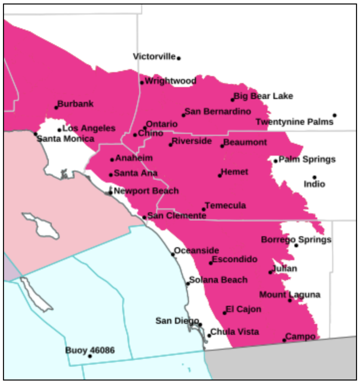
Also included in the red flag warning are inland San Diego and Orange counties and large swaths of Riverside and San Bernardino counties.

Map highlighting much of Southern California counties.

Red flag fire weather warnings announced for large swaths of Southern California from Monday morning through Tuesday night.

(National Weather Service)

Unlike the devastating Jan. 7-8 windstorm, where winds came out of the north and northeast, this week’s Santa Ana winds are expected to be more traditional, and will head from the east and northeast, forecasters said.

That’s why forecasters expect one of the most affected areas will be the Santa Ana wind corridor that extends from Palmdale toward points southwest, like Santa Clarita and Ventura, as wind heads toward the coast.

The strongest winds are expected from Monday afternoon through Tuesday morning, Schoenfeld said.

Forecasters also warned of dangerous seas along the coast. “Strong winds will create dangerous sea conditions which could capsize or damage small and large vessels,” the weather service said.

What makes this “particularly dangerous situation” so distinct from the four earlier warnings of this kind since November is that “this may be one of the driest, driest fire weather events that we’ve seen so far this year,” Schoenfeld said.

Relative humidity could be down to just 3% for some areas, with the driest air likely on Tuesday.

“So even though the winds are expected to drop as Tuesday progresses, we would urge people to not let their guard down, because we will be marching toward some of the lowest relative humidities during that time period,” Schoenfeld said.

Next weekend could bring some rain. There’s a 50% to 70% chance of rain starting Saturday and lasting for the following two days — but also a 20% to 30% chance of thunderstorms. That could bring heavy rain in some isolated areas, and the risk of flooding near recently burned areas.

The good news is that there’s a chance of mostly beneficial showers, which could help dampen the fires. And it’s a cold storm, which would bring snow levels down to 4,000 feet above sea level, which would bring snow to some mountain communities, Schoenfeld said.

“If we were to get enough beneficial rain, it would really be a game changer for the fire weather,” Schoenfeld said.

An extreme lack of rain plays a major role in explaining Southern California’s fire woes, where vegetation is parched and flammable, making brush far more likely to turn into a spot fire should an ember land on it.

The last time downtown L.A. got more than one-tenth of an inch of rain in a single calendar day was on May 5. It has now been 259 days since then — a record for downtown of not getting at least one-tenth of an inch of rain. The previous record for downtown was from Feb. 25–Nov. 3, 2008, when there was a record 253 consecutive days without a tenth of an inch of rain.

Downtown L.A. has received only 0.16 of an inch of rain since the water year began Oct. 1. That’s only 3% of the average at this point in the water year, which is 5.99 inches. The annual average rainfall for downtown is 14.25 inches.

Forecasters urged people to take action now to reduce the risk of any kind of ignition or a spread of fire, and to prepare for strong, damaging winds.

Residents should secure loose outdoor items such as patio furniture; adjust travel times between Monday night and Tuesday morning; charge up electronics, flashlights and battery packs; fill up the fuel tanks of emergency generators; and move cars away from trees that appear fragile, Schoenfeld said.

Experts warn people against keeping certain items within five feet of your home, such as outdoor furniture, umbrellas, garbage and recycling bins. Getting rid of all dead or living weeds is also a good idea, as is clearing gutters, roofs, decks, porches and stairways of flammable materials such as leaves and needles.

“And then when wind does start, stay away from trees, windows. And use extreme caution, again, with anything that could start a fire,” Schoenfeld said.

The new alert is an unprecedented fifth issuance of a “particularly dangerous situation” enhancement to a red flag warning in a single season by the weather service’s Oxnard office, which covers Los Angeles, Ventura, Santa Barbara and San Luis Obispo counties.

The first three times the office issued that warning were followed by fires igniting and spreading rapidly — the 19,904-acre Mountain fire in Ventura County in November, which razed 243 structures; the 4,037-acre Franklin fire, which spread rapidly in Malibu and destroyed 20 buildings in December; and this month’s Palisades and Eaton fires, among the most destructive and deadliest in modern California history.

“This wind regime [this week] is similar to the Mountain fire in a lot of ways,” Schoenfeld said. But, she added, “it doesn’t dip as deep into the San Gabriel Valley, as the Jan. 7 event did,” which helped fuel the Eaton fire rapidly and destroyed a wide swath of unincorporated Altadena.

The weather service in Oxnard started issuing “particularly dangerous situation” warnings only in 2020. It sent out two that year, in October and December. No others were issued until November 2024.

Graphic explaining the history of particularly dangerous situation red flag warnings

(National Weather Service)

The weather service decided to begin using the “particularly dangerous situation” tagline as a way to sound the highest kind of alarm for a red flag warning.

The need for, essentially, a red alert for a red alert became clear after the devastating Thomas fire of 2017, which destroyed 1,063 structures in Ventura and Santa Barbara counties; and the Woolsey fire of 2018, which destroyed 1,643 structures in Los Angeles and Ventura counties. Both were among the most destructive fires in Southern California’s modern history.

Amping up that messaging has seemed, sometimes, to work in the past. In late 2019, the weather service office overseeing the Bay Area referred to a red flag warning as potentially “historic” and “extreme,” which got significant attention. At the time, firefighters credited an extraordinary marshaling of firefighting resources as critical to keeping fires in Northern and Southern California from becoming far worse.

As of Sunday, the Palisades fire, which has burned more than 23,700 acres and killed at least 10 people, was 56% contained, according to the California Department of Forestry and Fire Protection. The Eaton fire, which has charred more than 14,000 acres and killed at least 17 people, was 81% contained.

There are still 27 people reported missing: 20 from the Eaton fire and seven from the Palisades, according to the Los Angeles County Sheriff’s Department.

Times staff writer Connor Sheets contributed to this report.


Source link


The Santa Ana wind forecast for Southern California has worsened, with officials saying the conditions will bring the “risk of large fire growth” beginning Monday.

The National Weather Service office in Oxnard on Sunday issued the most extreme version of its red flag fire weather warning, known as a “particularly dangerous situation” alert.

A large swath of Los Angeles and Ventura counties is likely to be affected, including burn areas in Malibu and Altadena, weather service meteorologists said. They warned residents to prepare for the event, which is expected to start at noon Monday and continue until 10 a.m. Tuesday.

Gusts of 50 to 70 mph are forecast for the coasts and valleys. In the mountains and foothills, gusts from 60 to 80 mph, with isolated gusts of 100 mph, are expected.

“We’d encourage people to prepare that evacuation plan for you, your loved one, pets — pack essentials, get that emergency go-bag ready just in case. Fill up gas for cars and generators, secure outdoor items and adjust travel plans,” said Rose Schoenfeld, a weather service meteorologist.

In addition to Malibu and Altadena, the warning includes Burbank, Santa Clarita, Oxnard, Thousand Oaks and Azusa. Ojai and Pasadena fall outside the boundary, Schoenfeld said.

The National Weather Service issued its extreme version of a red flag warning Sunday.

The National Weather Service said its extreme version of a red flag warning would go into effect Monday for parts of L.A. and Ventura counties.

(National Weather Service)

A conventional red flag warning — indicating critical fire weather conditions and rapid fire spread with any new ignition — is already in effect for wide swaths of the counties of Los Angeles, San Diego, Orange, Riverside, San Bernardino and Ventura from 10 a.m. Monday through 10 p.m. Tuesday.

The new alert is an unprecedented fifth issuance of a “particularly dangerous situation” enhancement to a red flag warning in a single season by the weather service’s Oxnard office, which covers Los Angeles, Ventura, Santa Barbara and San Luis Obispo counties.

The first three times the office issued that warning were followed by fires igniting and spreading rapidly — the 19,904-acre Mountain fire in Ventura County in November, which razed 243 structures; the 4,037-acre Franklin fire, which spread rapidly in Malibu and destroyed 20 buildings in December; and this month’s Palisades and Eaton fires, among the most destructive and deadliest in modern California history.

The weather service in Oxnard started issuing “particularly dangerous situation” warnings only in 2020. It sent out two that year, in October and December. No others were issued until November 2024.

Over the weekend, firefighters raced against the new threat of powerful winds to increase containment of the wildfires still burning in Pacific Palisades and Altadena — areas that fall under the red flag warning.

As of Sunday, the Palisades fire, which has burned more than 23,700 acres and killed at least 10 people, was 56% contained, according to the state Department of Forestry and Fire Protection. The Eaton fire, which has charred more than 14,000 acres and killed at least 17 people, was 81% contained.

There are still 27 people reported missing: 20 from the Eaton fire and seven from the Palisades, according to the Los Angeles County Sheriff’s Department.

Late Sunday, there were still communities near the Palisades fire that remained under evacuation orders, though areas where residents, and only residents, were being allowed in had expanded to the Palisades Highlands, with daily escorts at 10 a.m. and 5 p.m. Evacuation warnings were lifted in other areas.

Meanwhile in Altadena, areas north of Mendocino and Harriet streets remained under evacuation orders. South of that, the area north of Woodbury Road between Lincoln Avenue, on the west, and Lake Avenue, on the east, was still under an evacuation warning Sunday night.

The Altadena sheriff’s station remained closed after concerns about airborne contaminants sparked a California Division of Occupational Safety and Health complaint last week, though Sheriff Robert Luna said Sunday that he expected it would reopen in the early part of this week.

More than 2,700 federal and state fire personnel continued to battle the Eaton fire Sunday — slightly fewer than the day before as some fire crews were relieved from duty. Carlos Herrera, L.A. County Fire Department public information officer, said officials would continue to release firefighters — who have come from all around the country as well as Canada and Mexico — as containment increases.

But the department will remain in communication with weather experts to staff appropriately, “especially in Altadena in Mt. Lowe and Mt. Wilson — some spots where we’re looking on getting containment,” Herrera said. “We have plenty of resources.”

At a Sunday afternoon town hall, Cal Fire Operations Section Chief Jed Gaines echoed that sentiment — but with a hint of concern in light of the forecast for the days ahead.

“We are confident that this fire is going to stay within the current footprint it sits today,” he said, “but we are concerned if there are new starts in the area.”

More than 5,600 fire personnel remained attached to the Palisades fire Sunday, roughly the same number as the day before.

Melanie Miller, the Palisades incident’s public information officer, said crews were doing “contingency planning” in preparation for more wind, and were in a waiting stage to see whether a change in action would be needed or if some resources could be released.

Other regions affected by the warning include Santa Monica and the San Gabriel Valley. Areas outside the red flag warning zone include the L.A. Basin, such as downtown L.A., Torrance and Long Beach, and coastal San Diego and Orange counties.

Malibu resident Kathy King was bracing for what might come with the winds.

“I’m concerned we’re going to have a replay of what we saw a week ago, 10 days ago,” she said Sunday while grocery shopping. “We know once a fire gets started, it’s very hard to turn it around.”

Her home near Point Dume survived the Woolsey fire in 2018, when nearly all the others on her street burned. But the Palisades fire destroyed the real estate office where she works in Pacific Palisades. The new weather warning has her on high alert.

“I can’t even sleep when they predict that because I think I’ve got to be ready to jump in the car,” King said.

Michelle Harrison and her husband lost their home in an unincorporated area of L.A. County just outside the Malibu city limits when the Palisades fire erupted Jan. 7.

Now, Harrison fears for those who could face even more threatening weather in Malibu this week.

“It’s just tragic,” she said. “I hope they have enough firefighters here, which I think they do now, to stop” any fires that might break out in the coming days.

Red flag warning map

Red flag warnings, which indicate critical fire weather and rapid spread should ignition occur, are expected to be in effect for large swaths of Los Angeles, San Diego, Orange, Riverside, San Bernardino and Ventura counties starting Monday.

(National Weather Service)

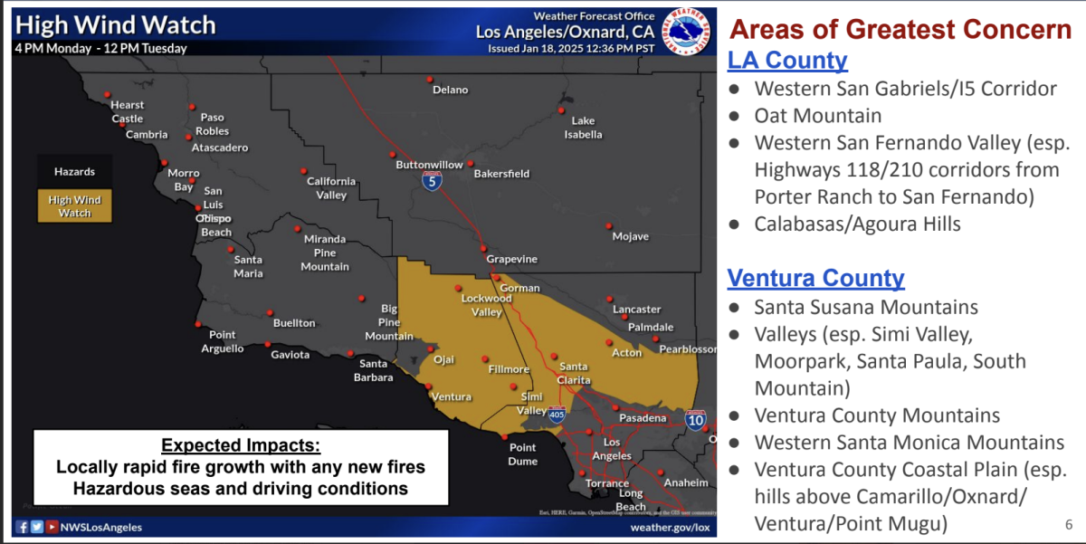
With this being more of a traditional Santa Ana wind event, which sees winds coming out of the east to northeast, Ventura County will be an area of great concern.

In L.A. County, the areas of greatest concern include the western San Fernando Valley, Calabasas, Agoura Hills, the western San Gabriel Mountains and the Grapevine section of Interstate 5.

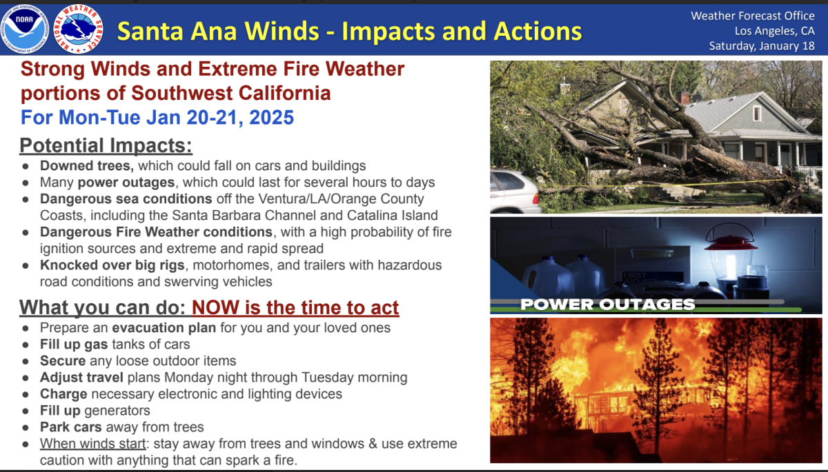
Residents should secure loose outdoor items such as patio furniture; adjust travel times between Monday night and Tuesday morning; charge up electronics, flashlights and battery packs; fill up the fuel tanks of emergency generators; and move cars away from trees that appear fragile, Schoenfeld said.

NWS infographic showing areas of greatest concern

(National Weather Service)

Experts warn people against keeping certain items within 5 feet of your home, such as outdoor furniture, umbrellas, garbage and recycling bins. Getting rid of all dead or living weeds is also a good idea, as is clearing gutters, roofs, decks, porches and stairways of flammable materials such as leaves and needles.

“And then when wind does start, stay away from trees, windows. And use extreme caution, again, with anything that could start a fire,” Schoenfeld said.

Santa Ana winds impacts

(National Weather Service)

Gusts could be so powerful they could knock over big rigs and motor homes and trigger power outages that could last days, the weather service said. And on Sunday evening, county public health officials issued a windblown dust and ash advisory, warning that the expected gusts could disperse ash throughout the county and reduce air quality — particularly in areas downwind of recent burn scars.

Very dry conditions are expected all week, with the driest Tuesday, the weather service said. Relative humidity could fall to as low as 5% in the western San Fernando Valley, Santa Clarita, Oxnard, Thousand Oaks and Fillmore.

Fire weather concerns will persist through the week, Schoenfeld said, with more Santa Ana winds possible by Thursday. The weather service could end the red flag warning Tuesday or extend it through Thursday.

There is some chance of rain in about a week. But, at this point, it doesn’t appear to be the kind of soaking that would be needed to end the fire season, Schoenfeld said.

There’s around a 50% to 70% chance of rain from Jan. 25 to 27, Schoenfeld said, and a 20% to 30% chance of thunderstorms.

“It doesn’t look like a really thoroughly wetting rain for a broad scope of the area,” Schoenfeld said. “That’s honestly bad news for our fire weather season going forward.”

Times staff writers Melody Gutierrez and Libor Jany contributed to this report.


Source link