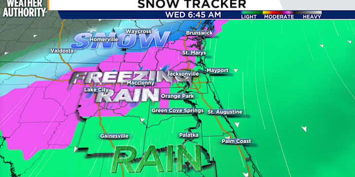
JACKSONVILLE, FLA – A rare winter storm is set to impact North Florida and southern Georgia on Tuesday night into Wednesday morning and it will bring the risk of ice and even some snow to the region.

The greatest threat will be ice forming Tuesday night into Wednesday morning, creating hazardous travel conditions from western Jacksonville and points north and west.

Here’s the breakdown:

  • While Georgia and the Florida Panhandle will see snow that sticks to the ground, snowflakes in Jacksonville are not likely.

  • A bigger concern for Northeast Florida is freezing rain, starting Tuesday night.

  • Wednesday morning could be hazardous for drivers everywhere except close to the river or east of the St. Johns River to the coast where ice is less likely on the roads.

Freezing rain is expected to begin in Southeast Georgia on Tuesday afternoon before shifting south into Northeast Florida after midnight Tuesday and lingering into the mid-morning Wednesday.

This poses a significant risk of ice accumulation, especially along and north of Interstate 10 toward Lake City, Macclenny, Homerville, Waycross, and Jesup.

Zones in pink for freezing rain.

Areas along the St. Johns River and back to the beaches should not be under the risk of ice as the coastal winds help to buffer the freeze.

Temperatures at dawn Wednesday.

While ice is the primary concern around Northeast Florida, snow can also target Georgia and the Florida panhandle with over an inch or more adding up on the ground.

Snow totals in inches with the heaviest bands starting in the Panhandle to northern Ware and Glenn counties Georgia.

Areas along and north of Waycross in Southeast Georgia have a medium chance (40-50%) of seeing up to 1 inch of snow.

There is also a low chance (5-15%) of up to 3 inches of snow north and northwest of Waycross, which could lead to major impacts.

Winter Storm warning until 1 PM in pink colors.

A Winter Storm Warning is in effect for snow and freezing rain late Tuesday through 1 p.m. Wednesday where the areas of greatest winter precipitation target inland Southeast Georgia, Suwanee River Valley, and near the Florida I-10 corridor.

The depth of the cold above the ground explains why snow is not likely in Jacksonville.

For Jacksonville to experience snow, a unique and precise combination of weather factors would need to converge — a long shot, indeed.

As of now the air above the ground in Jacksonville does not look cold enough for snow even though the surface will be freezing. This vertical atmospheric profile could result in sleet or freezing rain around Duval, Nassau, and counties west along I-10.

A warm layer over Jacksonville is expected to remain and prevent snow. If it does not develop then snow could fall Wednesday before sunrise.

The graphic below is a cross-section of the atmosphere through time with the forecast starting on Monday at the left and ending on Sunday at the right. The white areas are temperatures below freezing in the air column over Jacksonville. Freezing air shows up Wednesday morning at the surface but since the air is not freezing aloft snow is not likely.

Only two white areas representing freezing air are located at the bottom of the chart. Red and blue colors represent above freezing air in the lower 5000 feet of the atmosphere.

Compared to Waycross, you can see the atmospheric sounding of air is much colder with freezing (white areas) extending from the ground to the top of the chart representing freezing air for all snow.

Waycross cross-section atmospheric temperature forecast.

Key Messages:

  • Increasing confidence of snow and freezing rain impacts the watch area Tuesday evening through midday Wednesday.

  • Freezing rain potential greatest along/north of I-10 toward Homerville-Waycross-Jesup.

  • Snow potential is greatest north of Waycross.

  • Patches of road ice are possible across Southeast Georgia and portions of Northeast Florida early Wednesday morning.

  • Nightly freezes and dangerous wind chills are expected through Thursday.

Safety Actions:

  • Ice accumulation could cause significant power outages Tuesday night. Be sure to stock winter emergency supply kits for homes and vehicles.

Consider adjusting travel plans to stay off roads after 9 p.m. on Tuesday through Wednesday morning.

Copyright 2025 by WJXT News4JAX – All rights reserved.


Source link


An intense blast of arctic air is sweeping across much of the United States to start the week, following a storm system off the East Coast that dumped snow over the Mid-Atlantic and Northeast over the weekend. But as the those regions dig out from the snow, a rare and significant winter storm will threaten the Gulf Coast states and the Southeast beginning Monday night.

The bitterly cold air mass is affecting the western, central and eastern United States this week, causing temperatures to plunge far below normal for January. On Monday, high temperatures are expected to be 20 to 30 degrees colder than average.

Across the northern Plains and Upper Midwest, temperatures are expected to be in the negative teens and single digits. The Rockies, central Plains and Midwest are likely to see highs in the single digits to teens, while the East Coast, New England and the Mid-Atlantic brace for temperatures in the teens and 20s.

The snowstorm that moved through the Northeast and Mid-Atlantic on Sunday left some of the largest accumulations of the season. Accident, Md., just south of the Pennsylvania border, recorded 14.5 inches. In New York, the largest totals were in the southeast part of the state, north of New York City, with around eight inches in Fahnestock State Park, Highland Mills and Hopewell Junction. Central Park recorded 1.6 inches.

In Washington, D.C., which received a little less than an inch of snow on Sunday, organizers of President-elect Donald J. Trump’s inauguration, moved the swearing-in ceremony indoors for the first time since 1985. “Bitter cold conditions are expected” on Monday, the National Weather Service said, warning that highs in the teens to low 20s were likely, with gusts up to 30 m.p.h. likely bringing wind chills down to single digits and below zero.

Across the northern Plains and Upper Midwest, temperatures will only reach the negative teens and single digits. The Rockies, central Plains and Midwest will see highs in the single digits to teens, while New England and the Mid-Atlantic brace for temperatures in the teens and 20s.

The frigid temperatures will feel even more severe because of dangerous wind chills, particularly in the Rockies, northern Plains and Upper Midwest. These areas are forecast to have wind chills as low as 30 to 55 degrees below zero through Tuesday morning, levels that pose a severe risk of frostbite and hypothermia to anyone with exposed skin, the Weather Service warned. Even areas as far south as the south-central Plains and the Ohio Valley will experience subzero wind chills by the middle of the week.

The unusually cold weather is extending into regions less accustomed to harsh winter conditions, including the Gulf Coast and northern Florida. Numerous freeze warnings were in place, as subfreezing morning temperatures are likely to threaten sensitive plants and exposed plumbing. These frigid conditions are expected to persist for the next few days over eastern and southern parts of the country.

In addition to the dangerous cold, the combination of arctic air and a storm system will result in the potential for a rare and significant winter storm over the Gulf Coast states and the Southeast, beginning Monday evening in eastern and southern Texas and spreading eastward along the coast, reaching the Southeast by Tuesday and Wednesday.

The storm is forecast to sweep across Texas, Louisiana, Mississippi, Alabama, north Florida, Georgia and the Carolinas, said Marc Chenard, a meteorologist at the Weather Service. Heavy snow is expected along and near the Interstate 10 corridor, while sleet and freezing rain are forecast for parts of southern Texas, southeast Georgia and northern Florida.

These conditions are likely to lead to major travel disruptions, with flight delays and cancellations also anticipated, given these areas are not equipped to handle winter weather, Mr. Chenard added. Strong winds and the weight of snow on tree limbs may bring down power lines and cause sporadic power outages.

The National Weather Service has issued winter storm warnings for southern areas of Texas, Louisiana, Mississippi, Alabama and northwest Florida. Total snow accumulations over southeast Texas and southwest Louisiana are expected to be between two and six inches.

The bitter cold and winter storm impacts are expected to linger across the Southeast and eastern United States until at least midweek. Dangerous driving conditions and travel disruptions are likely to continue for a few days in the South after the storm clears, Mr. Chenard said, “given the cold air still in place, it might take a little while for things to melt out.”


Source link