Moderna headquarters, exterior view, in Cambridge, Mass.

Moderna headquarters, exterior view, in Cambridge, Mass.

Plexi Images/Universal Images Group Editorial via Getty Images


hide caption

toggle caption

Plexi Images/Universal Images Group Editorial via Getty Images

The U.S. Department of Health and Human Services announced it will award $590 million to Moderna to accelerate the development of influenza vaccines, including to protect against bird flu.

“Accelerating the development of new vaccines will allow us to stay ahead and ensure that Americans have the tools they need to stay safe,” outgoing HHS Secretary Xavier Becerra said in a statement on Friday.

The money will go to Moderna, the Massachusetts-based pharmaceutical company that previously developed a COVID-19 vaccine. Since 2023, Moderna has been working to create a “pandemic influenza vaccine” which would help protect against certain viruses, including the H5N1 bird flu.

The new funds build on the $176 million that HHS gave to Moderna last July. On Friday, Moderna said the additional funding will help pay for late-stage development, licensure of the vaccines and expanding clinical studies for additional subtypes of pandemic influenza to prevent other potential public health emergencies.

Over the past several months, bird flu has spread rapidly throughout the U.S.

It has mostly infected livestock and other mammals, but there have been at least 67 confirmed human cases so far, including one death in Louisiana, according to the Centers for Disease Control and Prevention. California currently accounts for more than half of human infections.

The public health risk remains low, but HHS Secretary Becerra said bird flu variants have proven to be unpredictable, which is why the virus is a top priority for the federal government.

On Thursday, the CDC issued an alert urging hospitals to speed up efforts to test people who they suspect have an infection.


Source link


An intense blast of arctic air is sweeping across much of the United States to start the week, following a storm system off the East Coast that dumped snow over the Mid-Atlantic and Northeast over the weekend. But as the those regions dig out from the snow, a rare and significant winter storm will threaten the Gulf Coast states and the Southeast beginning Monday night.

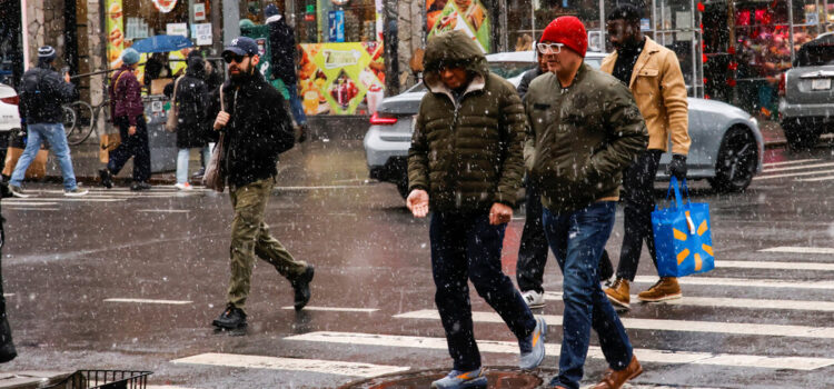
The bitterly cold air mass is affecting the western, central and eastern United States this week, causing temperatures to plunge far below normal for January. On Monday, high temperatures are expected to be 20 to 30 degrees colder than average.

Across the northern Plains and Upper Midwest, temperatures are expected to be in the negative teens and single digits. The Rockies, central Plains and Midwest are likely to see highs in the single digits to teens, while the East Coast, New England and the Mid-Atlantic brace for temperatures in the teens and 20s.

The snowstorm that moved through the Northeast and Mid-Atlantic on Sunday left some of the largest accumulations of the season. Accident, Md., just south of the Pennsylvania border, recorded 14.5 inches. In New York, the largest totals were in the southeast part of the state, north of New York City, with around eight inches in Fahnestock State Park, Highland Mills and Hopewell Junction. Central Park recorded 1.6 inches.

In Washington, D.C., which received a little less than an inch of snow on Sunday, organizers of President-elect Donald J. Trump’s inauguration, moved the swearing-in ceremony indoors for the first time since 1985. “Bitter cold conditions are expected” on Monday, the National Weather Service said, warning that highs in the teens to low 20s were likely, with gusts up to 30 m.p.h. likely bringing wind chills down to single digits and below zero.

Across the northern Plains and Upper Midwest, temperatures will only reach the negative teens and single digits. The Rockies, central Plains and Midwest will see highs in the single digits to teens, while New England and the Mid-Atlantic brace for temperatures in the teens and 20s.

The frigid temperatures will feel even more severe because of dangerous wind chills, particularly in the Rockies, northern Plains and Upper Midwest. These areas are forecast to have wind chills as low as 30 to 55 degrees below zero through Tuesday morning, levels that pose a severe risk of frostbite and hypothermia to anyone with exposed skin, the Weather Service warned. Even areas as far south as the south-central Plains and the Ohio Valley will experience subzero wind chills by the middle of the week.

The unusually cold weather is extending into regions less accustomed to harsh winter conditions, including the Gulf Coast and northern Florida. Numerous freeze warnings were in place, as subfreezing morning temperatures are likely to threaten sensitive plants and exposed plumbing. These frigid conditions are expected to persist for the next few days over eastern and southern parts of the country.

In addition to the dangerous cold, the combination of arctic air and a storm system will result in the potential for a rare and significant winter storm over the Gulf Coast states and the Southeast, beginning Monday evening in eastern and southern Texas and spreading eastward along the coast, reaching the Southeast by Tuesday and Wednesday.

The storm is forecast to sweep across Texas, Louisiana, Mississippi, Alabama, north Florida, Georgia and the Carolinas, said Marc Chenard, a meteorologist at the Weather Service. Heavy snow is expected along and near the Interstate 10 corridor, while sleet and freezing rain are forecast for parts of southern Texas, southeast Georgia and northern Florida.

These conditions are likely to lead to major travel disruptions, with flight delays and cancellations also anticipated, given these areas are not equipped to handle winter weather, Mr. Chenard added. Strong winds and the weight of snow on tree limbs may bring down power lines and cause sporadic power outages.

The National Weather Service has issued winter storm warnings for southern areas of Texas, Louisiana, Mississippi, Alabama and northwest Florida. Total snow accumulations over southeast Texas and southwest Louisiana are expected to be between two and six inches.

The bitter cold and winter storm impacts are expected to linger across the Southeast and eastern United States until at least midweek. Dangerous driving conditions and travel disruptions are likely to continue for a few days in the South after the storm clears, Mr. Chenard said, “given the cold air still in place, it might take a little while for things to melt out.”


Source link